Officials issue warnings as storm approaches
-
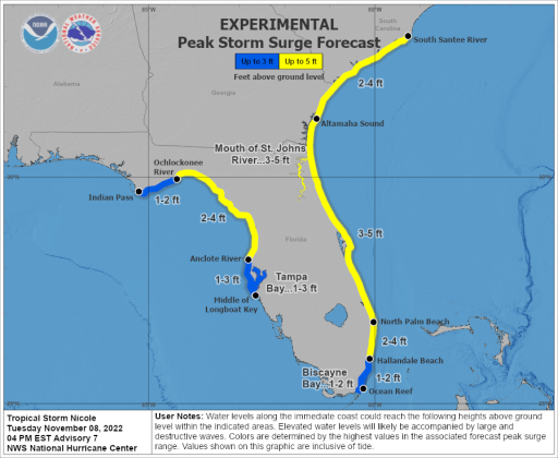 This graphic depicts the forecast storm surge inundation values that are provided in the tropical cyclone public advisory (TCP). These values represent the peak height the water could reach above normally dry ground somewhere within the specified areas. The yellow shaded areas include the St. Johns River to Lake George. (NWS)
Putnam County and several municipalities declared states of emergency Tuesday as experts forecast at least one to three feet of storm surge and strong winds in the coming tropical storm.
“It does look like it’s going to be pretty significant,” Public Safety Director J.R. Grimes warned at the Board of County Commissioners’ morning meeting. “People just need to stay tuned and keep an eye out and stay safe.”
Tropical Storm Nicole is forecast to strengthen to a Category 1 hurricane by Wednesday evening before making landfall in south or central Florida, according to a 4 p.m. briefing from the National Weather Service. Forecasters expect heavy rains and sustained winds of over 39 mph to arrive in Putnam County on Wednesday night and remain through Friday morning.
Putnam County was under a tropical storm warning as of 6 p.m. and areas along the St. Johns River are under a storm surge warning.
Putnam County Emergency Management is encouraging residents living in Evacuation Zone F — which includes Dunns Creek, Sportsmans Harbor and Federal Point — to evacuate. The following shelters will open Wednesday at 6 p.m.:
- Middleton-Burney Elementary School, 1020 Huntington Road, Crescent City
- Browning-Pearce Elementary School, 100 Marvick St., San Mateo
- A pet friendly shelter at Ochwilla Elementary School, 299 State Road 21, Hawthorne
- A special needs shelter at Kelley Smith Elementary School, 141 Kelly Smith School Road, Palatka
Putnam County schools, which were already scheduled to be closed Friday for Veteran’s Day, will also be closed Thursday. Court operations will also be suspended in Putnam County on Thursday and Friday.
Residents needing to fill sandbags can go to the following locations:
- Chesser Sand Pit, 145 W. Washington St., Hawthorne
- East Palatka Community Park, 223 Putnam County Blvd, East Palatka
- Huntington Landfill, 1551 County Road 308, Crescent City
- Palmetto Bluff Boat Ramp, 126 Boat Ramp Road, Bostwick
- Riverside Volunteer Fire Department, 101 Gail Drive, Satsuma
- Sportsmans Harbor vacuum station, 51 Sportsman Drive, Welaka
The cities of Palatka and Crescent City and the towns of Pomona Park and Welaka all declared states of emergency Tuesday. The town of Interlachen has scheduled an emergency meeting for Wednesday at 4:30 p.m.
Putnam County is expected to receive between 3 and 6 inches of rainfall during the storm, with more intense conditions projected in South Putnam, according to the National Weather Service. In an afternoon press release, Putnam County Emergency management forecast 1- to 3-foot storm surges along the St. Johns River, with more flooding possible, depending on the storm’s path.
All county and municipal offices will close at 5 p.m. Wednesday, according to Emergency Management.
Thursday’s Palatka City Commission meeting has been rescheduled for 6 p.m. Monday, the city of Palatka said in a press release. AE Engineering’s public presentation on its business incubator and feasibility study, previously slated for Wednesday evening, will also be rescheduled.
A call center will open Wednesday morning to field residents’ questions about the storm. The number is 386-329-1904.
Grimes stressed that areas that flooded during Hurricane Ian will likely get flooded again.
“I was in Dunns Creek yesterday afternoon. I went into Sportsmans Harbor in Welaka,” he said. “The water is already at the top of the bulkheads if it’s not already in the streets.”
The public safety director said that lingering floodwaters from September, coupled with the full moon, means that “all the stars are lining up” for intensified water damage.
Chairman Bill Pickens underlined the significance of Grimes' warnings.
“You definitely need to prepare for this storm. Don’t let it sneak up on you,” Pickens said. “This will be Irma-like.”
Commissioner Larry Harvey warned West Putnam residents to prepare for another round of flooding and washed-out roads, especially after weeks of dry conditions.
“Be very cautious. If you flooded before, it’s going to happen again. If your road washed out, it’s going to wash out,” he said. “So just protect you and your family as best you can.”
Commissioner Terry Turner encouraged residents to use their common sense and be mindful of their safety.
“If you feel insecure, go somewhere else,” he said. “The ground is soggy. If you live under a tree, a tree could fall. You’ve got a chance in a nice home or whatever, but if you live in a ‘49 mobile home, then you need to be more concerned.”
Above all, County Administrator Terry Suggs advised residents to prepare and keep informed.
“Follow the warnings,” he said. “Follow the advice that’s been out on our website through our emergency management folks. And just be safe.”
Copyright Palatka Daily News 2022 - all rights reserved.