Putnam expected to see wind, rain Wednesday, officials say
-
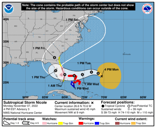 This is a map of Subtropical Storm Nicole's projected trajectory as of Monday afternoon..
Officials are warning Putnam County residents to prepare for potential flash flooding and storm surges later this week as a subtropical storm approaches Florida.
Subtropical Storm Nicole was east of the Bahamas on Monday afternoon and is forecast to become a hurricane before making landfall in southeast Florida, according to a 4 p.m. update from the National Hurricane Center. Gov. Ron DeSantis declared a state of emergency in Putnam County and 33 other counties in a Monday afternoon press release.
“I urge all Floridians to be prepared and to listen to announcements from local emergency management officials,” DeSantis said in the release. “We will continue to monitor the trajectory and strength of this storm as it moves towards Florida.”
Tropical storm-force winds will become possible in Putnam County beginning Wednesday, according to the Hurricane Center. Around two to four inches of heavy rain are also expected, most likely in the eastern portion of the county, Putnam County Emergency Management said in a Facebook post.
The St. Johns River is expected to rise one to three feet above normal levels, according to Emergency Management.
The National Weather Service warned of a possible “life-threatening storm surge” along the St. Johns as well as localized flash flooding near the river Thursday and Friday. A coastal flood watch is scheduled to go into effect in the St. Johns River Basin beginning Monday night.
“There is particular concern for areas that just experienced flooding from (Hurricane) Ian,” Emergency Management said in a social media post. “If you live in these areas, please start taking precautionary measures and keep up with local reports. We will have more information and direction for y'all tomorrow (Tuesday) morning.”
Emergency Management Specialist Danelle Choate advised residents to clear their yards of debris and set out sandbags if their home is prone to flooding. Sandbag pickup sites will be open at the following locations:
- Chesser Sand Pit, 145 W. Washington St., Hawthorne
- East Palatka Community Park, 223 Putnam County Blvd, East Palatka
- Huntington Landfill, 1551 County Road 308, Crescent City
- Palmetto Bluff Boat Ramp, 126 Boat Ramp Road, Bostwick
- Riverside Volunteer Fire Department, 101 Gail Drive, Satsuma
- Sportsmans Harbor vacuum station, 51 Sportsman Drive, Welaka
Choate said the county is still considering whether to open emergency shelters. As of Monday afternoon, she said Putnam County is expected to experience the worst of the wind and rain Thursday.
Choate reiterated that areas like Dunns Creek and Sportsmans Harbor in Welaka — some parts of which are still partly flooded from Hurricane Ian — will likely see more flooding.
“If you flooded during Hurricane Ian, you’re probably going to get flooded again,” she said.
Copyright Palatka Daily News 2022 - all rights reserved.