Time, location of Dorian landfall up in the air
-
 Putnam preps for Hurricane Dorian
 -
 Officials prep for Hurricane Dorian
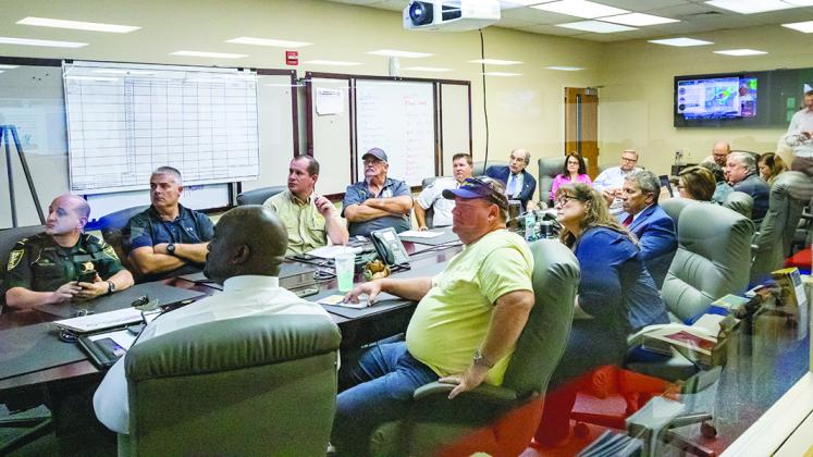
County and municipal officials who met at the Putnam County Emergency Operations Center on Thursday afternoon to plan a response for Hurricane Dorian heard plenty of good news – followed by a bit of bad news.
According to the National Weather Service, Hurricane Dorian, which was predicted Wednesday to make landfall near Cape Canaveral, has slowed down and taken a more southerly path. Thursday’s predictions show the storm could strike the state further south, possibly sparing Putnam County from a more direct hit.
Predicted heavy rains after the storm could mean significant problems for Putnam County in the days after the storm, however.
Al Sandrik, a meteorologist at the National Weather Service in Jacksonville, said although it is still early and things can change, two dominant may be a good sign for Putnam County.
According to a briefing by Sandrik, Dorian is expected to develop into a Category 3 storm, but models show it will likely make landfall significantly south of Putnam County.
Sandrik said Thursday the likelihood of strong winds in Putnam County is low and had dropped significantly over the previous 24 hours. Putnam could see winds in the 20 to 40 mph range with potential wind bursts up to tropical storm levels.
The news that Putnam County had a lower probability of sustained tropical storm winds came as a relief to many officials, but another bit of news caused concerns among those in attendance at the Dorian briefing.
The hurricane is expected to make landfall and drive toward the Lakeland and Kissimmee area before turning north and bisecting the state. The storm is projected to move slowly up the center of the state, dumping large amounts of rain as it moves north.
Much of the county could see between 10 and 15 inches of rain — perhaps as much as 20 inches in some areas — between Monday and Thursday, Sandrik said.
“The projected impact to our area has been delayed,” Putnam County Emergency Services Battalion Chief Paul Flateau said. “It slowed down and gives a bit more time to prepare.”
Despite the delay, county officials are still planning and encouraging the public to prepare for a strong weather event.
The storm, he said, is still unpredictable and is moving very slowly, meaning even small changes in direction might significantly change impacts.
“If the current forecast is accurate, it seems it’s going to be more of a flooding event,” Flateau said. “That can still be very dangerous and can knock out power and trees.”
Officials are not yet sure about storm surge or flooding, but Flateau said the projected rainfall is comparable to Hurricane Irma in 2017 during which there were storm surges of 3 and 4 feet.
Flateau said officials are urging people who live in coastal areas and flood-prone areas to monitor their situation carefully.
As of Thursday afternoon, no emergency shelters were opened.
“We’re breathing a bit of a sigh of relief right now,” Putnam County School District Superintendent Rick Surrency said. “We’re very apprehensive because we’ve been through this in the last couple years, and we don’t want to do anything too quick.”
Putnam County emergency shelters are all located in select school district buildings.
Surrency said schools would be open for classes Friday and officials would continue to meet over the weekend to make a decision about classes on Tuesday when, if projections held, Putnam County would receive heavy rain.
“Because it’s so far out, we’re not making any announcement on closures or shelters or anything until possibly (today) until we get more insight on the direction of the storm,” Surrency said.
prediction models being so close in agreement