County sandbag distribution to begin Monday; Palatka residents asked to curb yard waste
-
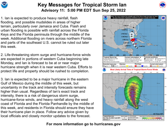 The National Weather Service issued this 5 p.m. advisory for Tropical Storm Ian on Sunday evening. The Putnam County Board of County Commissioners met Sunday in an emergency meeting to discuss the storm and hear about plans for potential impacts to this area. (National Hurricane Center graphic)
Key highlights Sunday:
- City of Palatka residents are asked to place yard waste curbside on Monday for a Tuesday pickup
- No shifts to school schedules as of Sunday evening
- County sandbag distribution was expected to begin Monday at 3 p.m. (locations listed below)
- Putnam County is expected to experience tropical storm force winds as early as Tuesday
- Plans to open an emergency shelter (if needed) are underway
- Concerns about Sunshine Law may impact procedures for how commissioners are updated regarding emergency operations
Putnam County officials, briefed on the latest track for Tropical Storm Ian, enacted a state of emergency on Sunday and discussed plans for the coming week.
The Putnam County Board of County Commissioners, during a special emergency meeting called Saturday morning due to the National Weather Service's forecasted path of Ian, voted unanimously to enact the state of emergency — an action that, very basically, allows the county to activate emergency response measures under the threat of a potential minor, major or catastrophic disaster. The governor's office had earlier issued an executive order declaring a state of emergency for all 67 Florida counties.
During the meeting at the Putnam County Government Complex Sunday, Public Safety Director J.R. Grimes briefed the commission on the morning's update for the storm.
"They're predicting now possibly a Category 4," said Grimes of the National Weather Service forecast. "Which, the further westerly track it (takes), for us, puts us in the upper right hand corner of the storm, which is the heaviest amount of rain and wind and we're still inside the cone of uncertainty at this point."
Grimes conveyed to commissioners that the weather service currently predicts between seven and nine inches of rain, if Sunday morning's hurricane model holds steady. Grimes said the county is working toward opening a shelter and the department expects to begin sandbag distribution at 3 p.m. Monday.
Putnam County Sandbag locations
- Huntington Landfill: 1551 County Rd 308, Crescent City
- East Palatka Community Park: 223 Putnam County Blvd., East Palatka
- Chesser Sand Pit: 145 West Washington St., Hawthorne
Are residents should bring their own shovels, emergency personnel stated. The locations are also expected to be open beginning at 9 a.m. Tuesday.
As of the National Weather Service 5 p.m. update, Tropical Storm Ian was about 200 miles southwest of Jamaica and was expected to produce heavy rainfall, flash flooding and possible mudslides in areas of higher terrain, particularly over Jamaica and Cuba.
"Life threatening storm surge and hurricane force winds are expected in portions of western Cuba beginning late Monday," the weather advisory states.
In Florida, the weather service states that flash and urban flooding will be possible across the Florida Keys and Florida peninsula through mid-week.
The NWS also warned of potential impacts to North Florida rivers.
"Additional flooding on rivers across northern Florida and parts of the southeast U.S. cannot be ruled out later this week," the NWS advisory states. "Ian is expected to be a major hurricane in the eastern Gulf of Mexico during the middle of the week. But uncertainty in the long term track and intensity forecasts is higher than usual."
Potential impacts to Putnam
Grimes told commissioners that the earliest potential for tropical storm force winds in Putnam County is expected to be sometime around Tuesday afternoon, but said the more likely arrival would be around Wednesday afternoon. Provided the storm route doesn't change much, slow down or speed up, Grimes expects the storm to be past the county on Friday.
"We're still continuing to monitor it and see what's going to come out in the updates ahead," Grimes said. "I think tomorrow is going to be really critical — and first thing Tuesday morning."
Commissioner Larry Harvey focused in on the rainfall expectations for the areas of West Putnam that have experienced flooding and impassable roads during rain events.
"Recently we've had just some — I hate to say minor rainstorms — but you know, a couple inches out in West End and it's really almost like a bomb went off on some of the roads."
"You know that roads are blown out just for two inches," said Harvey. "If we get seven and nine inches, we're gonna have major, major issues out there."
Harvey asked Grimes if the public safety department could make sure alerts would be made to the public about hazards and other concerns.
Grimes assured Harvey and other commissioners that the cities and county emergency public information officers and spokespeople would work together to provide consistent messaging.
Grimes said throughout the threat of the storm on the Putnam area, the Emergency Operations Center will be part of several daily briefings by phone with state officials and the National Weather Service: Each day at 8 a.m., with the National Weather Service; a call with the state watch office and National Hurricane Center will be held at 11:15 a.m.; At 1:20 p.m., a call will take place with the National Weather Service out of Jacksonville; At 5:15, a second call with the state Hurricane Center is set to occur.
Grimes said the county's sandbag operation is expected to begin Monday at 3 p.m.
The specifics of distribution were unclear as of 5 p.m. Sunday.
The public safety director said that all generators for the county were checked on Friday, as well as those at nursing facilities in the area, and staff would be checking operations at lift stations on Monday.
Commissioners were assured by Harvey that the levels at the Rodman Reservoir would be monitored throughout the storm.
Sunshine concerns: Commission attendance at Ops Center
County staff also informed commissioners that they were working on a plan with County Attorney Rich Kommando for commissioners to be briefed about the calls and updates "without threatening to violate the Sunshine."
"We're working with Mr. Kommando on potential solutions that would allow you all to get some of that information without having an issue," said Deputy County Administrator Julianne Holmes Young.
In response to a question from Commissioner Paul Adamczyk regarding the Sunshine Law concerns, Homes Young said that staff is looking at the possibility of creating a separate room for commissioners, where the conversation among staff and officials are isolated from policy board members.
"(The attorney's) advice is simply that you're there observing only, with no commentary, no questions," Holmes Young said. "If you have questions you would need to direct them to administration."
The deputy administrator told commissioners that she was advised in a legal opinion by the county attorney Sunday morning that the "act of you having a question could trip the threshold of a sunshine violation."
She said the act of asking a question to stimulate conversation about an action the county agency plans to take, should not involve two or more elected officials without a properly noticed public meeting.
As the emergency proclamation stands, the county board chair, currently County Chair Bill Pickins, is designated to be able to participate in the emergency operations meetings, Holmes Young said.
"What Rich is saying is just like on a normal daily basis, you wouldn't call the chairman and ask him a question," Holmes Young said. "You'd call administration and ask a question and administration would get you a solution or a resolution. The same scenario stands."
"(The attorney's) advice is simply that you can't engage in conversation," said the deputy administrator. "It's up to all of you whether or not you follow legal counsel's advice."
Commissioner Terry Turner said he didn't agree with the attorney on this issue.
"I absolutely believe that just because we've done something for 15 years, doesn't mean it means that we've been doing it correctly," said Turner. "But I also believe that I can't do my job as a county commissioner without getting briefings, without knowing what's going on… I just can't do it. Okay, if y'all decide that I'm not privy to that information, I'll dig it up on the street myself."
Turner said that he is not sure "the emergency order doesn't allow commissioners to go to the Emergency Operations Center and work together." He said in the past commissioners have helped cook food, feed people or helped in another way. Turner wanted specifics of the attorney's opinion in writing.
"It's not fair to put all of it on the chairman," said Turner. "To tell us we can't even go to EOC unless we sit in a separate room. It's just ridiculous, Julie. … If (the attorney) comes in and says that's what we've got to do, okay. But I'm gonna need to see it in writing."
City of Palatka
City staff on Sunday put out a notice requesting residents make sure they put out any yard waste and debris on Monday.
City waste disposal services will be collecting debris and yard waste on Tuesday. After that, the city asks residents to refrain from putting any waste curbside during the duration of the storm threat, so potential winds won't redistribute the waste around neighborhoods.
Putnam County Schools
Putnam County School District spokesperson Ashley McCool said that as of Sunday evening, no decisions had been made that impact area schools or scheduling.
McCool said district officials are meeting regularly with the emergency management team, monitoring the storm and expect to have more information Monday afternoon.
Town of Welaka
According to Welaka Mayor Jamie Watts, he met with town staff Sunday morning to discuss planning for the tropical storm.
Among the takeaways:
- Yard debris will be picked up Monday morning
- Public Works crews will be mowing around storm drains and checking stormwater drainage areas, as well as securing loose items at area parks
- A sandbag site is expected to open Monday for town residents as well as those who live just outside of town. A location for distribution was unclear as of Sunday evening.
- A special emergency meeting will be called for 5:05 p.m. Tuesday to enact a state of emergency
- Police Chief Mike Porath is expected to reach out to Five Oaks Rest Home and Sugar Mill Woods Apartments to determine if anyone with special needs requirements will need to be transported to a shelter, if that becomes a necessity. Town residents who are not at those locations but need shelter assistance are asked to contact Porath after 8 a.m. Monday at (386) 329-3191.
"Should the County open shelters, we will make the announcement should it become necessary for those in low-lying areas to evacuate," Watts said. "At this point, we are only making plans until we get a better idea of the storm's exact path."